I’m planning to hike parts of the Appalachian Trail (AT) this summer. I am unsure at this point where I’ll start and stop, but it’ll be in NH / ME. My notes are below. This is mostly for my personal use but could be useful for others to see what I’m planning to bring for longer treks. I’ve hiked many parts of the Whites with my family, so I know the terrain and area well there.
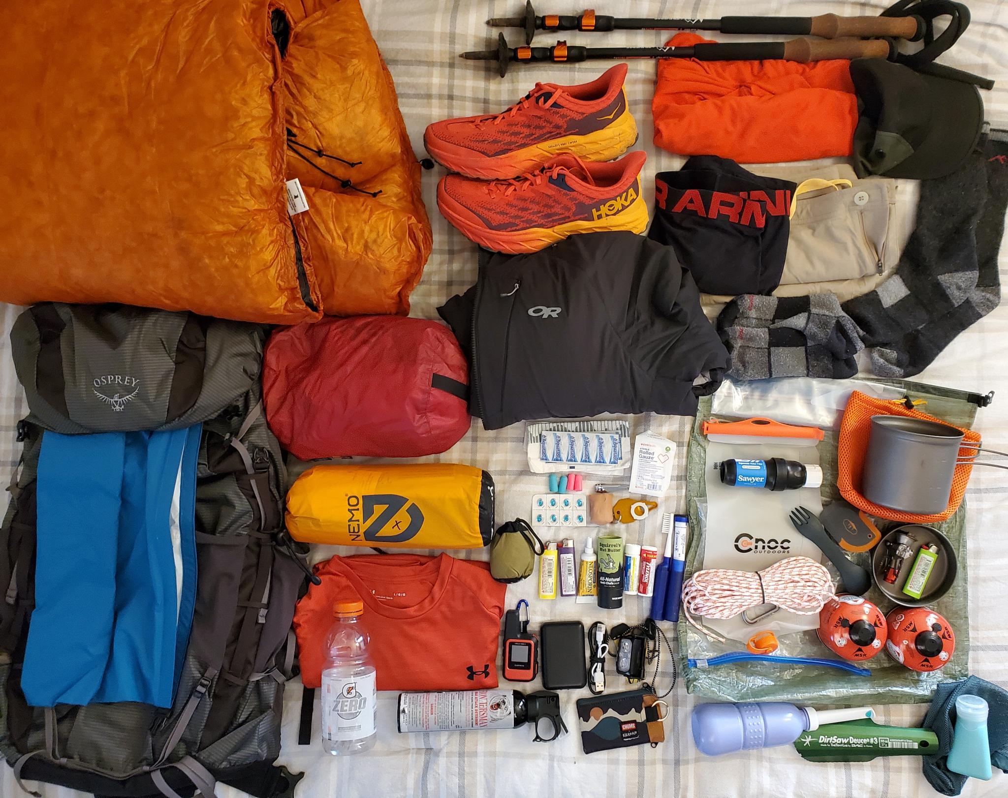
All the gear listed below. It looks like a lot, but it packs nicely organized.
Gear
6.5 lbs: “Big 4” Large Items
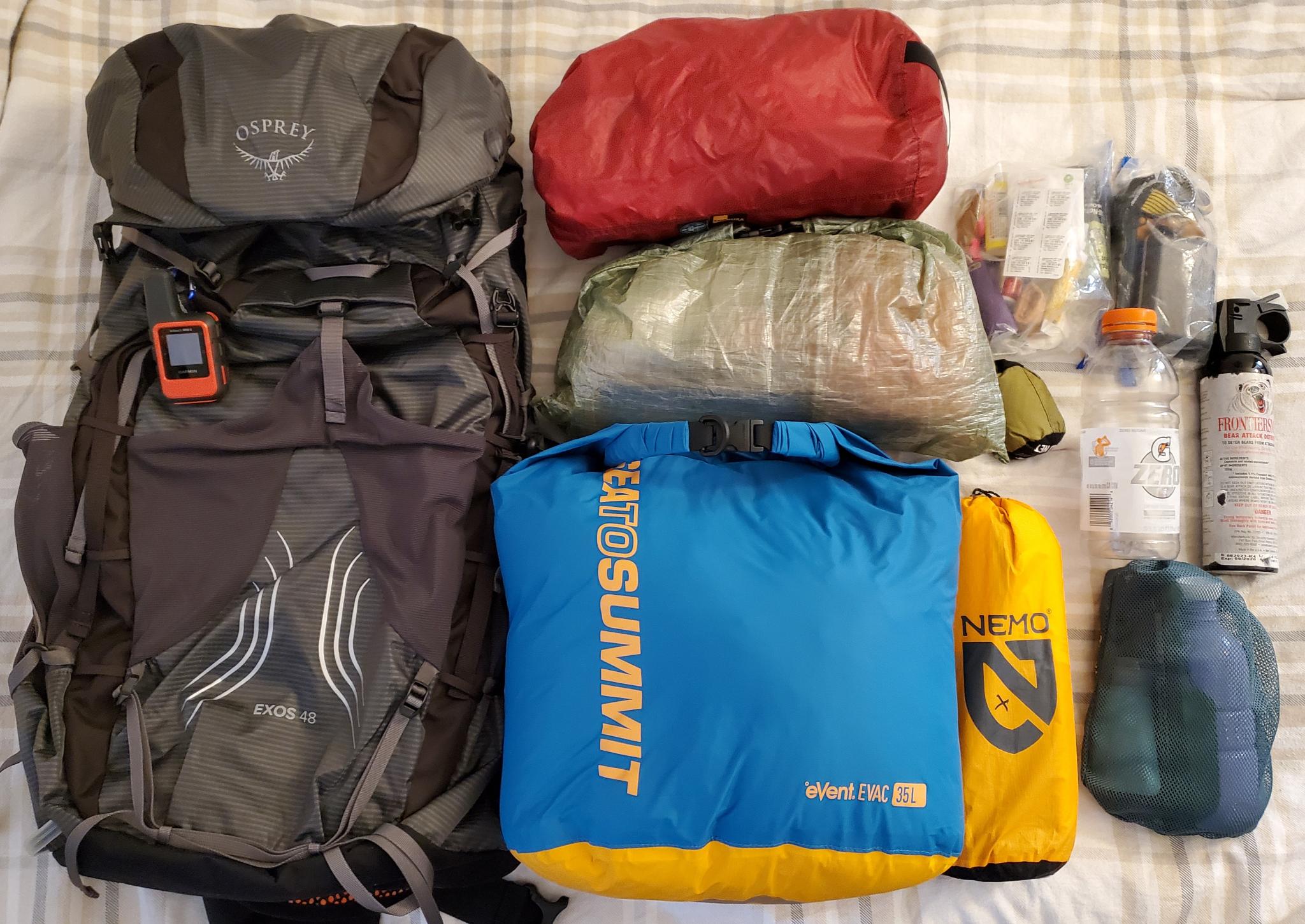
- (3.1 lbs) backpack – Osprey Exos 48L + SeaToSummit 35L eVac Dry Bag as pack liner
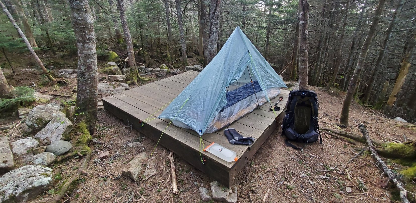
- (1.1 lbs) tent – ProTrail LI + stakes + stake bag
- (1.2 lbs) sleeping quilt – EE Revelation 30 degree
- (1.1 lbs) sleeping pad – NEMO Tensor Inflatable
1.5 lbs: Packed Clothing
Weight only includes what’s packed in backpack. I’ll be treating much of this with Permethrin and/or Nikwax.
- (WORN) hat
- (WORN) trekking poles
- (WORN) Darn Tough socks
- (WORN) synthetic pants
- (WORN) synthetic sun hoodie
- (WORN) synthetic Under Armour underwear
- (WORN) trail running shoes – HOKA Speedgoat 5
- (PACKED) bug net
- (PACKED) waterproof puffy jacket
- (PACKED) synthetic short sleeve shirt
- (PACKED) extra pair of Darn Tough socks
14 lbs: Food & Water
- (7 lbs) 4 days of food
- (5 lbs) 2L of water (1L Gatorade bottle + CNOC Vecto for reserve)
- (1.5 lbs) MSR PocketRocket stove, Toaks 1100ml pot, fuel, 2x lighters, pot scraper, spork
- (0.4 lbs) food bag (ZPacks), 50ft rope, carabiner, freezer zip loc bags
- Sawyer Squeeze water filter + spare rubber gasket
- Aqua Tabs water filtering tablets
2.5 lbs: Electronics, Med Kit, Other
Electronics & Navigation
- Garmin inReach Mini
- zipper pouch with id, cards, cash
- phone, power bank, Nitecore NU25 headlamp
- USB-C cable, mini USB cable
Medical, Toiletries, Other
- trowel, bidet, unscented castile soap
- toothbrush + paste, nail clippers, tick puller
- Leukotape, gauze, foot cream (Squirell’s Nut Butter), ear plugs
- neosporin, tylenol, ibuprofen, loperamide
For the 100MW I’ll equip a can of bear spray too, just in case.
Food
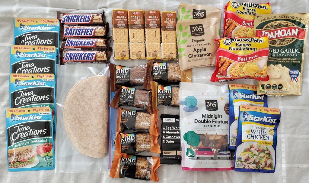 What I packed for 3days/2nights in the White Mountains. ~7,000 calories. The trail mix is ~1,500 calories alone. Snacks for breakfast or cook oatmeal if I want to spend the time. Tuna wraps for lunch plus candy and snacks. Trail mix all day to keep fueled up. Dinner is ramen + potatoes + chicken. Should have a good handful of snacks left over.
Drinks:
- NUUN sport hydration caffeine tablets
Snacks/Breakfast/Lunch:
Use tortillas/english muffins to make wraps with anything
- peanut butter
- granola bars / oatmeal / crackers / cookies / jerky / peanut butter crackers
- almonds / cashews / raisins / dried fruit / trail mix / yogurt- or chocolate-covered nuts
- meat packet for tortilla fill (tuna / chicken / etc.)
Dinners:
Generally, mix potatoes/stuffing/ramen with some meat for protein. Add olive oil for extra calories.
- Freeze-dried dinners (like Mountain House, etc.)
- Ramen + meat + instant mashed potatoes/stuffing
- Mashed Potatoes + meat
- Mac and Cheese + meat
- Meat options: tuna, chicken packets, etc.
Training
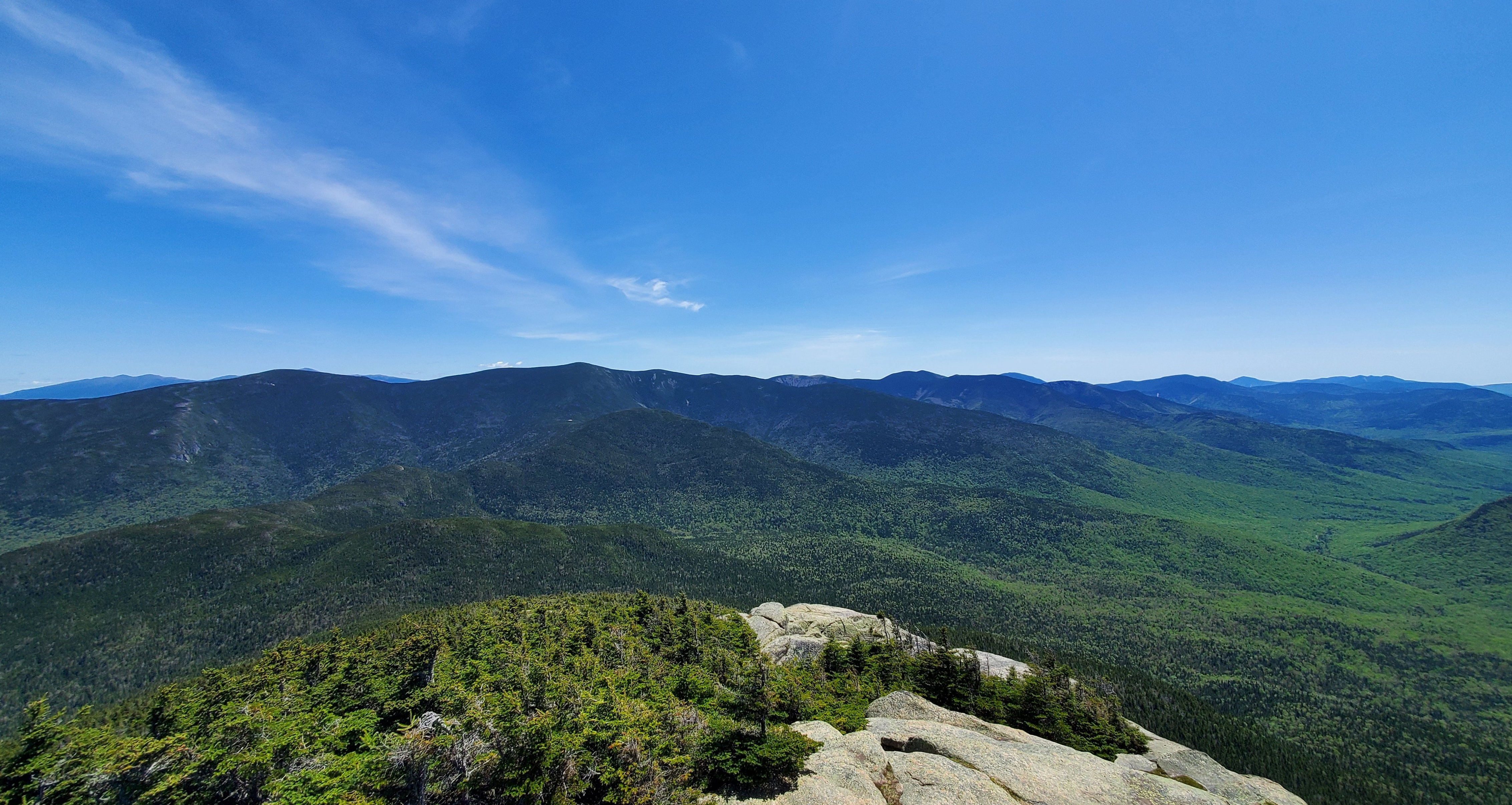
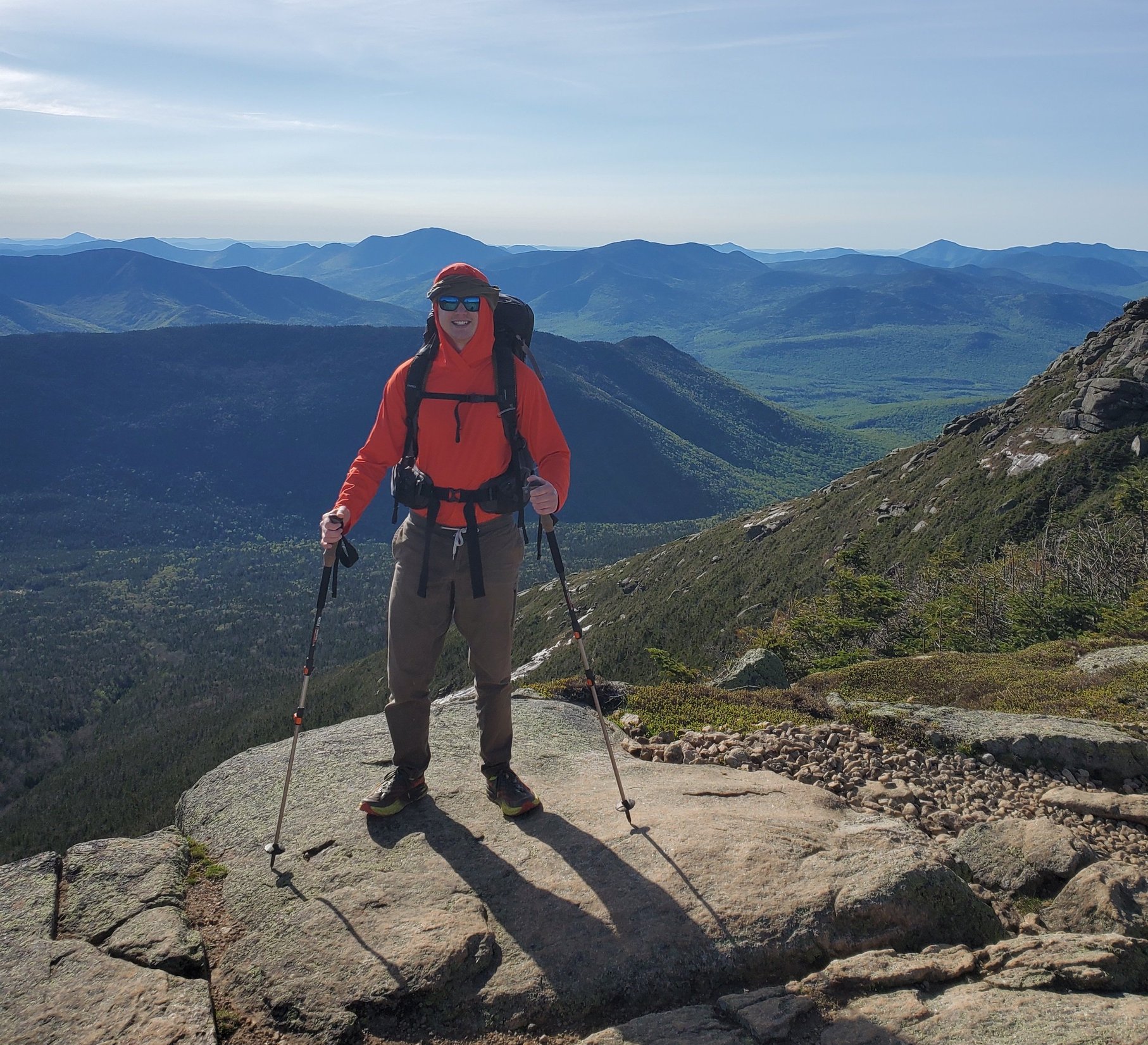 Up at 5,000’ on New Hampshire’s Franconia Ridge. It was sunny, windy and beautiful!
 Ready for the night at Mt. Garfield.
 The view from Mt. Garfield, NH.
NOBO NH AT Route Shelters / Campsites
- – mile 1756: HANOVER NH START
- 1757: Velvet Rocks Shelter (lean-to + tent space)
- 1767: Moose Mountain shelter (lean-to + 3-4 tents total)
- 1772: Trapper John (lean-to + several tent spots)
- 1779: Smarts Tent Site (2-3 tents only) (Cabin is up the mountain)
- 1784: Hexacuba Shelter (lean-to + 2 dirt tent pads)
- – 1790: NH Rt. 25A RESUPPLY OPTION
- 1791: Ore Hill Campsite (several tent spots)
- 1797: Wachipauka Pond (few small campsites on shores of spur trail)
- 1800: Jeffers Brook Shelter (lean-to + several tent spots)
- 1807: Beaver Brook Shelter (lean-to + one tent platform & space for handful of other tents)
- – 1809: Kinsman Notch NH Rt. 112 RESUPPLY OPTION
- 1816: Eliza Brook Shelter (lean-to + 5 earthen tent pads)
- 1820: Kinsman Pond Shelter ($10, space in cabin and 4 wooden tent platforms)
- 1822: Lonesome Lake Hut
- – 1825: I93 LINCOLN RESUPPLY OPTION
- 1827: Liberty Springs Campsite ($10, many tent spots)
- 1831: Greenleaf Hut
- 1835: Garfield Ridge Campsite ($10, shelter + 7 tent platforms)
- 1838: Galehead Hut
- 1840: Guyot Shelter (shelter + 6 tent platforms)
- 1845: Zealand Falls Hut
- 1849: Ethan Pond Shelter ($10, shelter + wooden tent platforms)
- 1852: Crawford Notch Campground
- – 1853: US Rt. 302 Crawford Notch RESUPPLY OPTION
- 1859: Mizpah Spring Hut & Nauman Tentsite ($10, wooden tent platforms)
- 1863: Lakes of the Clouds Hut
- – 1865: Mt. Washington!
- 1871: Madison Spring Hut
- 1874: Osgood Tentsite (5 wooden tent platforms)
- – 1878: Pinkham Notch RESUPPLY OPTION
- 1884: Carter Notch Hut
- 1891: Imp Campsite ($10, shelter + 5 wooden tent platforms)
- 1898: Rattle River Shelter (lean-to + 3 earthen tent platforms)
- – 1900: NH Rt. 2 GORHAM FINISH
NOBO ME AT Route Shelters / Campsites
- – mile 1900: US Rt. 2 GORHAM RESUPPLY OPTION
- 1907: Trident Col Campsite (0.2mi off trail) (5 tent pads)
- 1912: Gentian Pond Shelter (shelter + 5 wooden tent platforms)
- 1917: Carlo Col Shelter (0.3mi off trail) (shelter + 5 wooden tent platforms)
- 1921: Full Goose Shelter (shelter + 4 wooden tent platforms)
- 1924: Tentsite (unofficial ~6 tent sites)
- 1926: Speck Pond Shelter ($10, shelter + 6 wooden tent platforms)
- 1932: Baldate Lean-to (shelther + 6-8 tent sites)
- 1936: Frye Notch Lean-to (shelter + 3-4 tent sites)
- 1942: Surplus Pond Road (3-4 tent space)
- 1946: Hall Mountain Lean-to (shelter + several tent sites)
- 1948: Sawyer Brook (old AT shelter + possible tenting area)
- 1950: South Arm Road (official tenting site opposite bank of river from road)
- 1959: Bemis Mountain Lean-to (shelter + 4 earthen tent pads)
- 1967: Sabbath Day Pond Lean-to (shelter + large wooden tent platform)
- 1972: Little Switch River Pond (6 dirt tent sites)
- 1979: Piazza Rock Lean-to (shelter + many wooden and dirt tent platforms)
- 1985: Redington Stream Campsite (0.2mi off trail) (2 wooden tent platforms + five dirt tent pads)
- 1988: Poplar Ridge Lean-to (shelter + limited tenting space)
- 1990: Sluice Brook Loggin Road (maybe space for tenting North on logging road)
- 1996: Spaulding Mountain Lean-to (shelter + little tenting space)
- 2002: Crocker Cirque Campsite (0.1mi from trail) (3 wooden tent platforms + space for about 6 more)
- – 2010: ME Rt. 27 RESUPPLY OPTION
- 2011: Cranberry Stream Campsite (ground space for 4-5 tents)
- 2014: Horns Pond Lean-tos (multiple shelters + a dozen dirt tenting pads)
- 2017: Bigelow Col Campsite (5 wooden tent platforms)
- 2019: Safford Notch Campsite (several tent pads, 2 wooden tent platforms)
- 2024: Little Bigelow Lean-to (shelter + several tents space)
- 2026: East Flagstaff Road (space for several tents)
- 2027: Flagstaff Campsite (unmarked, space for 2-3 tents)
- 2032: West Carry Pond Lean-to (shelter + two tent sites + space for more tends in woods)
- 2042: Pierce Pond Lean-to (shelter + several tenting sites - some more east along pond shore)
- 2046: Kennebec River (NEED TO USE FREE CANOE SHUTTLE ACROSS - open 9-11am until June 30, then 9-2pm until Sept 30)
- 2052: Pleasant Pond Lean-to (shelter + locals can camp nearby?)
- 2061: Bald Mountain Brook Lean-to (shelter + tenting site near brook)
- 2065: Bald Mountain Pond Lean-to (shelter + several tent sites)
- 2070: Tentsite (logging road clearing)
- 2073: Horseshoe Canyon Lean-to (shelter + space for 2-3 tents)
- – 2083: Monson ME RESUPPLY (100 Mile Wilderness southern edge)
- 2086: Leeman Brook Lean-to (shelter + space for tents)
- 2093: Wilson Valley Lean-to (shelter + minimal space for tents)
- 2098: Long Pond Stream Lean-to (shelter + minimal space for tents)
- 2102: Cloud Pond Lean-to (shelter + 3-4 tent space on pond shores)
- 2109: Chairback Gap Lean-to (shelter + space for tents)
- 2114: Peasant River Campsites ($12, must reserve in advance)
- 2119: Carl Newhall Lean-to (shelter + space for half dozen tents)
- 2121: Sidney Tappan Campsite (space for about half dozen tents)
- 2126: Logan Brook Lean-to (shelter + minimal tent area 0.1mi north)
- 2129: East Bran Lean-to (shelter + minimal tent space)
- 2138: Cooper Brook Falls Lean-to (shelter + 6-8 tent spots)
- – 2141: Jo-Mary Road (tenting possible) RESUPPLY DROP POSSIBLE
- 2146: Antlers Campsite (space for many tents)
- 2149: Potaywadjo Spring Lean-to (shelter + about half dozen tent spots)
- 2152: Mahar Landing (dense forest; handful of tents space, go across the road for flatter tenting area grounds)
- 2154: Nahmakanta Stream Lean-to (space for several tents)
- 2157: Nahmakanta Lake (space for tenting)
- 2158: Nahmakanta West Beach (space for 3-4 tents)
- 2159: Wadleigh Stream Lean-to (shelter + few dirt tent pads, space for a few more tents)
- 2167: Rainbow Stream Lean-to (shelter + lots of tent space)
- 2169: Rainbow Lake Dam (4-5 tent sites on both sides of dam)
- 2171: Rainbow Spring Campsite (5 tents space)
- 2179: Hurd Brook Lean-to (shelter + large tenting area)
- 2182: Abol Pines (2 lean-tos, 3 tenting sites) (first come first serve but can be reserved up to 7 days in advance)
- 2192: The Birches Campsite (only for 100mi+ thru hikers) (reserve by signing up when entering park at Abol Bridge)
- 2192: Katahdin Stream Campground (must reserve in advance)
- – 2197: Baxter Peak, Katahdin (FINISH)

Maintaining positivity on a steep section between Mt. Liberty and Mt. Lafayette.
Cheers,
Daniel